


Vernon-National Guard Armory, Lamar County, Alabama
About
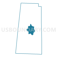
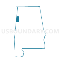
Outline

Summary
| Unique Area Identifier | 522192 |
| Name | Vernon-National Guard Armory |
| County | Lamar County |
| State | Alabama |
| Area (square miles) | 25.28 |
| Land Area (square miles) | 25.28 |
| Water Area (square miles) | 0.01 |
| % of Land Area | 99.97 |
| % of Water Area | 0.03 |
| Latitude of the Internal Point | 33.78152220 |
| Longtitude of the Internal Point | -88.08292770 |
Maps

Graphs
Select a template below for downloading or customizing gragh for Vernon-National Guard Armory, Lamar County, Alabama


Neighbors
Neighoring Voting District (by Name) Neighboring Voting District on the Map
- Blooming Grove, Lamar County, AL
- Crossville-Lawrence, Lamar County, AL
- Fairview-Sizemore, Lamar County, AL
- Moscow South, Lamar County, AL
- Strickland-Kingville, Lamar County, AL
- Vernon West, Lamar County, AL